Feeds:
Posts
Comments

Archive for October, 2012

For absolutely no reason at all I’m starting this post with a photo of a carrot from our garden:

On Sunday Tara and I took part in the last orienteering meet of the year organized by the Rocky Mountain Orienteering Club at Anderson Farms. Yup, it’s time for another corn maze! Last year this was the first corn maze and first orienteering meet I’d ever done. This year (and for the first time in any orienteering meet) I managed to hit all the controls without error and placed a respectable 5th (a bit shy of 4 minutes behind the winner). Full results.

Unlike last year, we didn’t stay too long after the race to enjoy the other festivities at Anderson Farms. Well, Tara, Carol, Claire and I did try the steer-post roping.

See you next year Anderson Farms!

Read Full Post »

Thursday and Friday’s new snow demanded to be hiked in come Saturday. I figured NCAR would be a less busy parking lot for my later-than-usual start to the day and picked up the Mesa Trail to Bear Canyon and on to Green Mountain.

The sun was coming out and warming up the flatirons while snow still lingered in the canyons (will this last all winter? or melt off before the next real storm?).

Clouds rolled in and cooled off the views.

Winds shook the trees of their snowy burdens.

Few people were seen until the summit of Green Mountain, always a popular destination.

I hustled back the way I’d come, but stopped near NCAR to watch some mule deer feasting below.

Read Full Post »

Good friends joined us for a weekend in Estes Park at the YMCA to hang out in a cabin. A little miniature golf started out Saturday morning.

Then a two hour horseback ride with Jackson Stables.

We passed the Fern Lake fire.

Back at the cabin was another excellent meal.

And a roaring fire.

Read Full Post »

Saturday I decided to start training for an upcoming trail marathon (one I’ll mostly walk) by doing an out-n-back hike on the Mesa Trail of 13+ miles from Chautauqua.

Grey skies and occasional drizzle keep me moving toward the South Mesa Trailhead and the autumn-color cottonwoods there.

While the views of the flatirons are great, I kept a look out for the smaller photo ops just off the trail.

On the return trip I had the sighting of the day near the Big Bluestem trail junction when a fox ran across the trail and gave me just enough time to fish out my point-n-shoot camera for a shot before running over the hill.

On Sunday Tara and I again ventured to the far side of Denver for another orienteering meet at Chatfield State Park (results link). Feeling good about our 3rd and 4th place finishes in the Orange (intermediate) distance event a few weeks prior, we both signed up for the harder and longer Green course. I learned that I really need to to learn the feature codes and other bits of esoterica on orienteering maps and maybe slow down a whole lot and increase my accuracy. The straight-line distance for the 14 control points and the finish was 6.6 km, and I ended up running 7.3 miles. Suffice to say, I couldn’t hold a bearing going to CP #4, couldn’t find #5 for the life of me, had trouble with #7 and overshoot #9 (finally locating #10 and back-sighting to reach #9). I thought the control points were much harder to locate on this course than the event we did at Cherry Creek State Park. Still, I’m psyched to get better at this sport and to stop thinking that all my off-trail hiking experience will get me through this event. Too bad the season is largely ending.

Read Full Post »

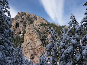
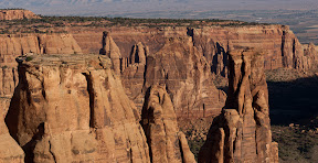
It’d been over two years since I visited Colorado National Monument, and then I’d climbed Independence Monument without ever exploring the main roads of the park. This time I left town after work and pulled into the Saddlehorn Campground after dark to setup camp and fall asleep in the air of the desert’s edge. Waking up before dawn I drove north to the Grand View pullout and found another photographer already setup. Joining him with my own gear I setup to catch the morning light on Independence Monument.

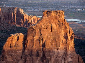
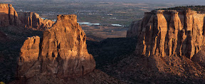
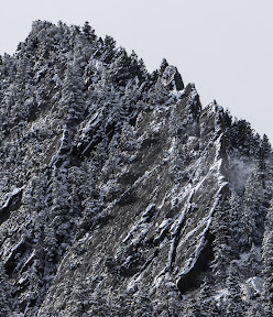
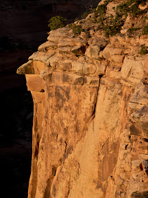
When the best light was gone he packed up and took off and I turned around and look 180 degrees away from what we had been shooting and found a golden cliff with the canyon behind still very dark.

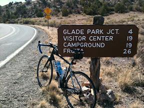
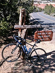
I’d toyed with the idea of signing up for the Saturday Tour of the Moon bike ride around these same roads, but decided on the low-cost option of riding the same route (only starting/stopping at the campground) on Friday instead. The ride direction signs, aid stations and volunteers weren’t out today, so I’d get a couple bonus miles in as well on my own 65 mile ride out of the Monument, through the peaceful farm/ranching roads north of Fruita, pass the too-developed lands east of the Monument then back up the Monument’s east entrance during the heat of the day.

The ride across the monument was the most beautiful I’d ever done. The afternoon winds and non-existent shoulder were the only negatives, but more than made up by the lack of traffic and great view points right off the road.

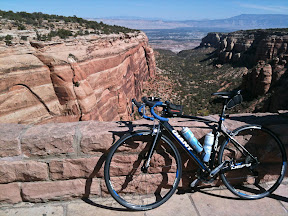
The road wasn’t completely level, so even from the marked high point I still found myself churning up some inclines on the remaining miles back to camp.

Now my to-do list has grown to coming back and riding the Monument road in the opposite direction. After arriving back at camp I cleaned up slightly and drove downhill into Fruita for a late lunch and beer at the Suds Bros. Brewery.

Cloudy eastern skies skunked my sunrise trip back to Grand View the next morning, but I scouted Monument View as a potential photography spot for a later trip.

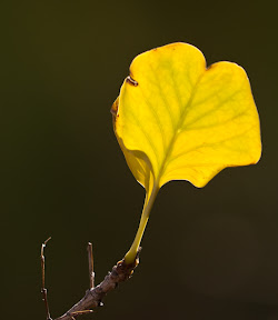
I spent the rest of the morning taking a short stroll into Ute Canyon while the major cycling event went by on the roads above.

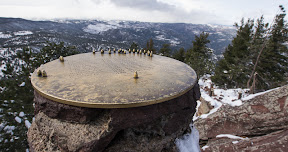
Negotiating the heavy bike traffic back out the Monument I stopped at the Balanced Rock view point wishing I’d see some desert bighorns but mostly watching cyclists speed downhill.

Read Full Post »